-
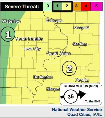 Map for Friday Afternoon Weather (Scroll to the right for more images)
 -
-
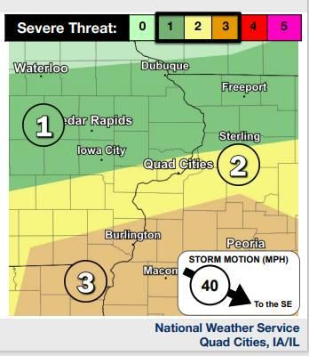 Map for Sunday
Key Messages
â— Severe weather is possible this morning and again this afternoon and evening. Damaging winds to 70 mph, large hail to the size of quarters, and tornadoes are possible.
â— Severe thunderstorms are possible Sunday as well. There is less certainty on location of storms.
A Line of Storms This AM
Tornadoes
Large Hail
Damaging Winds
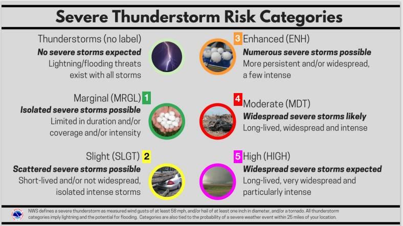
Severe Threats
A complex of showers and storms is forecast to move into eastern Iowa and northwest Illinois this AM but may not reach eastern sections until around midday. Additional development is possible Friday PM.
Be weather aware and ready to act!
Have multiple ways to receive warning information!
Low threat for an isolated tornado
Up to quarter size hail
Severe Weather This Afternoon
Key Messages
âž” Thunderstorms are expected to redevelop this afternoon as a cold front pushes through the area. Some of these storms could be strong to severe.
âž” Timing is Noon - 8PM across eastern Iowa, northeast
Missouri, and northwest Illinois.
Hazards Damaging winds & large hail are the main threats A few tornadoes can’t be ruled out
Actions
â— Have multiple ways to receive warnings.
â— When thunder roars, go indoors!
Severe Weather Potential Sunday May, 26 2024
Key Messages
âž” Storms are expected to in the morning. These storms are not currently expected to be severe.
âž” Storms will redevelop in the afternoon and move to SE with a cold front pushing through the area.
âž” Exact location of thunderstorm redevelopment is uncertain.
Hazards
Damaging winds, large hail & tornadoes are possible
Actions '
â— Have multiple ways to receive warnings.
â— When thunder roars, go indoors!
Comments
Submit a CommentPlease refresh the page to leave Comment.
Still seeing this message? Press Ctrl + F5 to do a "Hard Refresh".